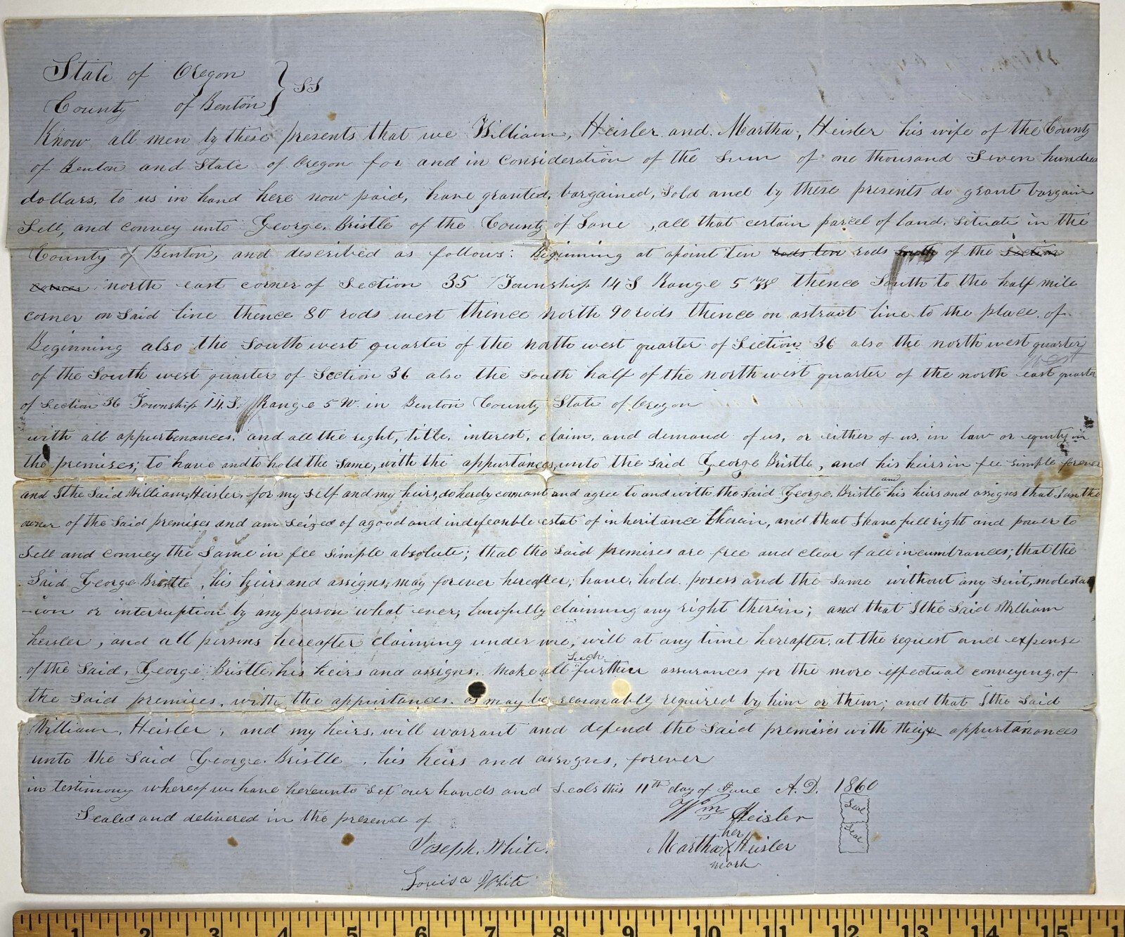
RARE Important ms Document 1860 Benton County Oregon Signed by Pioneers Heisler

When you click on links to various merchants on this site and make a purchase, this can result in this site earning a commission. Affiliate programs and affiliations include, but are not limited to, the eBay Partner Network.

RARE Important ms Document 1860 Benton County Oregon Signed by Pioneers Heisler:
$2400.00
RARE Early Oregon Document
Benton County
Large Land contract between
William Heisler and George BristleEarly Oregon PioneersSigned by Heisler, Judge Joseph White et. al.dated 1860
For offer, nice old pieces of ephemera! Fresh from a prominent estate. Never offered on the market until now.Vintage, Old, Original, Antique, NOTa Reproduction - Guaranteed !!
Important early Eugene OR piece of history.A large piece of land in Benton County - originally owned by William Heisler and sold to George Bristle (?) for $1,700 - a lot of money in 1860. Document signed byWilliam Heisler and his wife Martha, Joseph White (settler of Monroe ) and wife Louisa, and Eugene P Perham. See below for biographies of some of these people.
Manuscript ink on both sides - large folio sized paper. Nice watermarks, dated 1856. In very good condition. Fold marks. NOTE - will be sent folded, as found.Please seephotos. If you collect19thcentury Americana history, American documents, United States of America, etc.this is a treasureyou will not see again!Add this to your image orpaper/ ephemera collection.Important genealogy research importance too. Combine shipping on multiple offer wins! 3388
White's MillCorrespondence from the Benton County Historical Society, compiled by Collections Manager Mary Gallagher.Joseph White, born in Allegeny County, PA, arrived in Oregon on Oct. 1, 1851 and secured a claim on the Long Tom River in the location of the present community of Monroe, OR on June 25, 1853. His claim was located in T14S, R5W WM, section 33 (information from Genealogical Material in Oregon Donation Land Claims, Vol. II). At the time that he secured his claim, there was a small settlement called Starr’s Point located approximately one mile north of his claim. When Joseph White established a sawmill on his claim, the few business concerns in Starr’s Point moved near the sawmill The first business moved to “White’s Mill”* in 1854, and the town of Monroe was platted in 1857 on White’s claim. It is possible that Joseph White platted the town. You can check the Benton County plat map for Monroe; his name would be on the map if he platted the town. The post office continued with the Starr’s Point name until 1874 according to one source. The documentation that you seek concerning White and his sawmill can be found in David D. Fagan’s History of Benton County, Oregon (1885), p. 334.*”White’s Mill” is referred to in a 1938 WPA Interview by Frank Reader. His father, Samuel Reader, took over the mill from White.source for:Born in Allegheny County, PennsylvaniaArrived in Oregon on October 1, 1851reference Land Patent 1853White's Mill near Starr's Pointnotes: I did check the plat map and "White's Mill" does appear on the map. -APLand PatentsPatentee: JOSEPH WHITE Acres: 160 Issue Date: 5/20/1874 Land Office: Roseburg Authority: September 27, 1850: Oregon-Donation Act (grant) (99 Stat. 496) Document Nr.: 1650 Accession/Serial Nr.: ORRAA 015455 BLM Serial Nr.: ORRAA 015455NE 33/ 14-S 5-W No Willamette OR Benton
? What is source for Birth Information: August 16, 1824, Allegheny county, PennsylvaniaEarly Benton CountyTax Rolls
In 1848 Milton White (on June 30) and Asa White (on August 28) filed land claims in Benton County (vol 8, pg 58) Oregon Historical Records IndexThere may be a clue in the Benton County tax rolls for 1855 and 1856. This was very much frontier territory and it is not unreasonable to assume the WHITE households in the county had some relations:Benton County Tax Rolls1855 1856David WhiteJason M. White Jason M. WhiteJoseph White Joseph WhiteSanford White Sanford WhiteSarah White David White is mentioned in George Hunter's book, joined Captain Munson's Company I, Benton County Volunteers along with George Hunter, George Elliott, Lint Starr, Richard and Thomas Richardson, Wesley and Warren Hinton and Al Lloyd.1850 Census, Benton County - there is a John White (age 27, born Tennessee), wife Caroline (age 28, born in Virginia); children John (age 6, born in Virginia), Octavia (age 4, born in Missouri) and Ardina (M, age 0, born in Oregon Territory).1860 Census, Benton CountySamuel H White, age 30, born in Missouri; Elliot Whitlow householdSanford White (age 42, born in Kentucky) and Clarisa White (age 49, born in Ohio)1860 US Census, Butte Precinct, Benton County, Oregon[1]Joseph White. age 32, born in PennsylvaniaLouisa White. 22, born in IndianaRosanna F White, 5, born in OregonJames W White. age 3, born in OregonGeorge M White. age 1, born in OregonIn 1864 estate documents for a Nancy White were filed in Benton County.Born 1826 in PennsylvaniaReminiscences of an Old TimerAutobiography by George Hunter, brother of Joseph White's wife, Louisa Hunter.Asserted Joseph White was born in Pennsylvania in 1826 and went West in 1849.Census Records1860 and 1880 state Joseph was born in PennsylvaniaWilliam Heisler, and Lark Vantterpool, all of whom, with the exception of Combs and Slayton, locatedn the present site of Prineville.William Heisler was the pioneermerchant of Prineville and BarneyPrine was the first saloon keeper.Heisler established his store in 1SJ1,and continued business for seven oreight years.The Dalles Times-Mountaineer, December 19, 1891Oregonian: Died, at his home on Columbia Slough, near Peninsular station, on the 9th inst., Eugene L. Perham, aged 65 years. Judge Perham came across the plains to Oregon in 1850, was twelve years a resident of Benton county, serving two terms as county clerk, and resided twenty years in Wasco county, serving one term as county judge of that county. He leaves a wife, six sons and two daughtersBenton County is one of the 36 counties in the U.S. state of Oregon. As of the 2023 census population estimates, the population was 99,355.[1] Its county seat is Corvallis.[2] The county was named after Thomas Hart Benton, a U.S. Senator who advocated American control over the Oregon Country. Benton County is designated as the Corvallis, OR Metropolitan Statistical Area, which is included in the Portland–Vancouver–Salem, OR–WA Combined Statistical Area. It is in the Willamette Valley.
HistoryBenton County was created on December 23, 1847, by an act of the Provisional Government of Oregon.[3] The county was named after Democratic Senator Thomas Hart Benton of Missouri, an advocate of the doctrine of Manifest Destiny and the belief that the American government should control the whole of the Oregon Country. At the time of its formation the county included all the country west of the Willamette River, south of Polk County and running all the way to the California border in the south and the Pacific Ocean in the west.[4]
The county was created out of lands originally inhabited by the Klickitat, who rented it from the Kalapuyas for use as hunting grounds. All aboriginal claims to land within Benton County were ceded in the Treaty of Dayton in 1855. Portions of Benton County were taken to form Coos, Curry, Douglas, Jackson, Josephine, Lane and Lincoln Counties, leaving Benton County in its present form.
The city of Marysville, later renamed Corvallis, was made the county seat in 1851. The city briefly was the capital of Oregon.[5] In 1862 Corvallis became the site of the Oregon State Agricultural College, known today as Oregon State University.
GeographyAccording to the United States Census Bureau, the county has a total area of 679 square miles (1,760 km2), of which 676 square miles (1,750 km2) is land and 2.7 square miles (7.0 km2) (0.4%) is water.[6] It is the fourth-smallest county in Oregon by land area and third-smallest by total area.
Adjacent countiesPolk County (north)Lincoln County (west)Linn County (east)Lane County (south)National protected areasSiuslaw National Forest (part)William L. Finley National Wildlife RefugeDemographicsHistorical populationCensus Pop. Note %±1850 814 —1860 3,074 277.6%1870 4,584 49.1%1880 6,403 39.7%1890 8,650 35.1%1900 6,706 −22.5%1910 10,663 59.0%1920 13,744 28.9%1930 16,555 20.5%1940 18,629 12.5%1950 31,570 69.5%1960 39,165 24.1%1970 53,776 37.3%1980 68,211 26.8%1990 70,811 3.8%2000 78,153 10.4%2010 85,579 9.5%2020 95,184 11.2%2023 (est.) 97,713 [7] 2.7%U.S. Decennial Census[8]1790–1960[9] 1900–1990[10]1990–2000[11] 2010–2020[1]2020 censusAs of the 2020 census, there were 95,184 people, the racial make up of the county was 75.9% non-Hispanic white, 1% African American, 0.6% Native American, 6.7% Asian, 6.1% of two or more races. Residents of Hispanic or Latino ancestry made up 9% of the population.
2010 censusAs of the 2010 census, there were 85,579 people, 34,317 households, and 19,256 families residing in the county.[12] The population density was 126.6 inhabitants per square mile (48.9 inhabitants/km2). There were 36,245 housing units at an average density of 53.6 units per square mile (20.7 units/km2).[13] The racial makeup of the county was 87.1% white, 5.2% Asian, 0.9% black or African American, 0.7% American Indian, 0.2% Pacific islander, 2.3% from other races, and 3.6% from two or more races. Those of Hispanic or Latino origin made up 6.4% of the population.[12] In terms of ethnicity, 22.6% reported German ancestry, 16.1% English, 13.5% Irish, and 3.6% were American heritage.[14]
Of the 34,317 households, 24.2% had children under the age of 18 living with them, 45.3% were married couples living together, 7.3% had a female householder with no husband present, 43.9% were non-families, and 28.2% of all households were made up of individuals. The average household size was 2.35 and the average family size was 2.87. The median age was 32.1 years.[12]
The median income for a household in the county was $48,012 and the median income for a family was $71,763. Males had a median income of $50,282 versus $35,387 for females. The per capita income for the county was $26,177. About 7.7% of families and 19.1% of the population were below the poverty line, including 13.6% of those under age 18 and 5.5% of those age 65 or over.[15]
2000 censusAs of the 2000 census, there were 78,153 people, 30,145 households, and 18,237 families residing in the county. The population density was 116 people per square mile (45 people/km2). There were 31,980 housing units at an average density of 47 units per square mile (18/km2). The racial makeup of the county was 89.16% White, 0.84% Black or African American, 0.79% Native American, 4.49% Asian, 0.24% Pacific Islander, 1.92% from other races, and 2.56% from two or more races. 4.66% of the population were Hispanic or Latino of any race. 18.2% were of German, 11.6% English, 8.9% Irish and 7.0% American ancestry. 91.1% spoke English, 4.1% Spanish and 1.0% Chinese as their first language.
There were 30,145 households, out of which 28.40% had children under the age of 18 living with them, 50.40% were married couples living together, 7.20% had a female householder with no husband present, and 39.50% were non-families. 26.10% of all households were made up of individuals, and 6.70% had someone living alone who was 65 years of age or older. The average household size was 2.43 and the average family size was 2.95.
In the county, 21.30% of the population was under the age of 18, 20.20% was from 18 to 24, 26.70% from 25 to 44, 21.40% from 45 to 64, and 10.30% was 65 years of age or older. The median age was 31 years. For every 100 females there were 99.10 males. For every 100 females age 18 and over, there were 97.80 males.
The median income for a household in the county was $41,897, and the median income for a family was $56,319. Males had a median income of $42,018 versus $29,795 for females. The per capita income for the county was $21,868. About 6.80% of families and 14.60% of the population were below the poverty line, including 10.60% of those under age 18 and 4.90% of those age 65 or over.
Benton County has the lowest church attendance per capita of any county in the nation (25% / Community Population(As of 2023)
Corvallis 61,087North Albany 11,273Philomath 5,838Adair Village 1,018Monroe 763Lewisburg 569Mary’s River Estates 400Crescent Valley 336Vineyard Mountain 321Country Estates 259Alpine 258Palestine 223Alsea 220Asbahr-Pilkington 191Chinook 182Dry Creek 178Summit 177Kings Valley 147Wren 134Nash 130Flynn 128Cascade View 113Hope 107Ridgewood 103McDonald Forest Estates 90Rosewood Estates 88Greenberry 88Caldwell Hills 84Panoramic Acres 84Bellfountain 78Oakwood Heights 76Noon 76Raguse 72Merloy-Steele 68Pheasant Meadows 64Harris 64Blodgett 58Dawnwood 56Brownly-Marshall 56Hawk Crest 48Green Acres 46Hoskins 46West Hills Acres 40Lobster Valley 40Hidden Valley 36Glenbrook 32Nashville 32Alder 32Kopplein 26Country Hills 24Dawson 20CitiesAdair VillageAlbany (part)Corvallis (county seat)MonroePhilomathCensus-designated ValleySummitUnincorporated HillCascade ViewChaparral HeightsChinookCountry EstatesCountry HillsCrescent ValleyDawnwoodDawsonDry CreekFlynnGlenbrookGreen AcresGreenberryHawk CrestHidden ValleyMary’s River EstatesMcDonald Forest HeightsPalestinePanoramic AcresPheasant MeadowsRaguseRidgewoodRiverview HeightsRosewood EstatesWest Hills AcresWrenVineyard MountainPolitics and governmentFor a long time, Benton County strongly favored the Republican Party due to its significant Yankee influence. In the 1932 presidential election, it was the only county in the state to vote for Herbert Hoover instead of FDR. Along with Riverside County in California, it was one of only two counties in the Pacific States to be held by Hoover that year. As late as 1960,[17] Benton was the most Republican county in the traditionally Republican state of Oregon, which at that point had never supported a Democrat other than FDR for president, except for 1912 when the Republican Party was divided and a very narrow victory in 1868. Up to 1984, Benton County had voted for a Democratic presidential candidate only four times, in the above-mentioned 1868 election plus the national Democratic landslides of 1912, 1936, and 1964. In 1964, Lyndon Johnson became the first Democrat to win an absolute majority of the county's vote since Horatio Seymour.[18]
The Republican edge in the county narrowed from the 1970s onward, culminating when it swung from a five-point victory for Ronald Reagan in 1984 to a nine-point victory for Michael Dukakis in 1988. Since then, Benton County has become a strongly Democratic county, and is usually the second-strongest Democratic bastion in the state, behind only Multnomah County (Portland). This is largely due to the leanings of Oregon State's student body and staff, closely tracking with Democratic gains in other counties influenced by college towns. No Republican has come within nine percentage points of carrying Benton County since 1988. Overall, Benton County is a reliable state bellwether, having voted for Oregon's statewide winner in every presidential election since 1948, along with Hood River County.
Since 1972, Benton County has been a home rule county, meaning that the citizens have full control over the county charter, rather than using a standard charter issued by the state.[19] The voters have chosen to eliminate the traditional elected county offices of Assessor, Treasurer, Surveyor, Justice of the peace, and Clerk. Currently, they only elect three County Commissioners and a Sheriff.[20][21]
The three current Benton County Commissioners are Chair Pat Malone, Xanthippe Augerot, and Nancy Wyse. They are all members of the Democratic Party and have served since 2019, 2017, and 2021; respectively. Wyse and Augerot's current terms expire in January 2025, while Malone's is up in January 2023.[21][22][23]
The current Benton County Sheriff is Jef Van Arsdall. He was appointed to the office in March 2021 to fill the remainder of the term of retiring sheriff Scott Jackson.[24]
Benton County is currently one of 11 counties in Oregon in which therapeutic psilocybin is legal.
RARE Important ms Document 1860 Benton County Oregon Signed by Pioneers Heisler:
$2400.00
Related Items:
Extremely Rare And Important Fedchenko Precision Regulator Clock
$55000.00
A VERY IMPORTANT AND RARE ROMAN MARBLE HEAD OF HERCULES OR A BARBARIAN.
$33695.00
KPM PORCELAIN PLAQUE "OTHELLO" RARE ARTIST SIGNED COLLECTIBLE IMPORTANT
$9800.00